27-02-2015 04:01 PM CET
europeanspaceagency posted a photo:

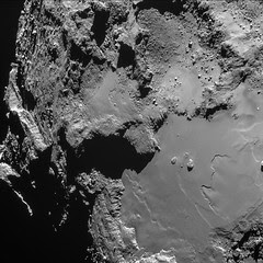
This single frame Rosetta navigation camera image was taken from a distance of 15.3 km from the surface of Comet 67P/Churyumov-Gerasimenko, at 16:12 GMT on 18 February 2015. The 1024 x 1024 pixel image frame has a resolution of 1.3 m/pixel and measures 1.3 km across.
More information and the original image via the blog: CometWatch: The challenges of a close flyby
Credits: ESA/Rosetta/NAVCAM – CC BY-SA IGO 3.0
This work is licenced under the Creative Commons Attribution-ShareAlike 3.0 IGO (CC BY-SA 3.0 IGO) licence. The user is allowed to reproduce, distribute, adapt, translate and publicly perform this publication, without explicit permission, provided that the content is accompanied by an acknowledgement that the source is credited as 'ESA - European Space Agency’, a direct link to the licence text is provided and that it is clearly indicated if changes were made to the original content. Adaptation/translation/
27-02-2015 10:28 AM CET
europeanspaceagency posted a photo:

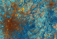
This false-colour image from the Spot-5 satellite was acquired on 28 September 2011 over central Belgium, capturing the capital city of Brussels (left).
Zooming in on the city, we can see a number of large parks, such as the Parc du Cinquantenaire or Jubelpark in the city’s European Quarter – home to the institutions of the European Union. Brussels is the de facto capital of the EU, and is a major centre for international politics.
Further west, we can see the Parc de Bruxelles or Warandepark, where the Royal Palace of Brussels and Belgium Parliament are located.
Northeast of the city, we can see the runways of the Brussels Airport.
Darker blue areas throughout the image depict thick vegetation cover, such as the city parks and the large Sonian Forest south of Brussels. Stretching over 4400 hectares, the forest is home to animals such as deer, red squirrel and wild boar. Brown bear and wolf also once roamed this area, but have disappeared through human influence and changes in the ecosystem over hundreds of years.
In the upper right is the city of Leuven in the Flemish Region. The city is home to the headquarters of Anheuser-Busch InBev – the world’s largest brewing group that includes brands such as Beck's, Budweiser and Stella Artois.
This image is featured on the
Earth from Space" video programme
Credit: Airbus Defence and Space
댓글 없음:
댓글 쓰기